

26 May 2021
Our fascinating journey to discover global monitoring technologies continues in May with a deep-dive into the theme of climate change with the noteworthy images from the 2021 Telespazio and e-GEOS Calendar: Love Planet Earth created in collaboration with National Geographic Italia.
Satellite shots are a great starting point to delve into Leonardo’s commitment and contribution to achieving the Sustainable Development Goals (SDGs) of the United Nations 2030 Agenda. Developing the potential offered by space technology to support the planet’s sustainable growth is one of the pillars of the Be Tomorrow – Leonardo 2030 strategic plan and of Leonardo’s Sustainability Plan.
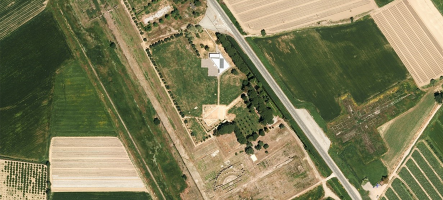
Liwa Oasis. We’re near Abu Dhabi in the United Arab Emirates. Here, a palm tree plantation is testament to reforestation projects currently underway in the area. Rows of trees not only provide a defence against the advancing sand dunes, but also a barrier against climate change and its consequences, such as desertification.
These plantations were captured in images for the month of May of the Love Planet Earth calendar associated with SDG 15 of the UN 2030 Agenda: Life on Land.

Liwa Oasis, Abu Dhabi, UAE. Sentinel-1 © ESA (2020). Processed by e-GEOS
“Love Planet Earth” calendar – Shots associated with May 2021
Thanks to the evolution of satellite Earth monitoring technology, phenomena like climate change can be dealt with and countered increasingly effectively, supporting international projects. An example of this is the Copernicus Earth observation programme, dedicated to monitoring our planet and its environment for the benefit of all European citizens, developed by the European Union in collaboration with the European Space Agency (ESA), to which Leonardo makes an important contribution through its Electronics Division and joint ventures Telespazio and Thales Alenia Space.
Delving deeper into the theme, we speak to Lucia Luzietti, Engineering and Services Provisioning - Head of Emergency Services and Operation of e-GEOS.

Lucia Luzietti
What can satellites do to monitor resources on the planet and fight climate change?
Today, satellites are fundamental; they allow us to improve our understanding of the effects of past extreme events. Through this, we can better understand what could happen in similar situations in the future and recalibrate models that do not correctly represent natural phenomena, in order to better plan mitigation. Thanks to this information, we can understand how to make our urban centres more resilient to extreme natural disasters.
Climate change has not only impacted the severity of natural disasters, but their frequency too. According to a UN study that compared 1980-1999 and 2000-2019, the number of these events grew from 4,000 to over 7,000, linked also to deforestation and a need to establish measures to monitor natural resources and fight climate change.
Total disaster events by type: 1980-1999 vs. 2000-2019

Excerpt from: Human Cost of Disasters, an overview of the last 20 years. Centre for Research of Epidemiology and Disasters. UN Office for Disaster Risk Reduction
Since 2012, e-GEOS has led the industrial consortium that provides the European Commission Copernicus EMS Rapid Mapping service with support of civil protection work at the European and global levels during disasters of natural or other causes, such as humanitarian crises. In such cases, satellites play a key role. The moment we receive a request, the first thing we do is try to understand what is happening in the field by verifying with the first satellite that can acquire an available image to immediately reconstruct details of the situation before the event itself using archival images of roads, buildings, infrastructure, etc. In the case of floods, for example, it is crucial to analyse the impact on infrastructure, urban areas and agriculture. What we do, in coordination with other production sites of the Rapid Mapping Consortium, is provide – as soon as possible – 24/7 information on affected areas from satellite data.
What are the features and advantages of this service?
There are two services offered by Copernicus that follow the various phases of emergency support:
- Copernicus EMS Rapid Mapping, dedicated to emergency support, which allows us to quickly provide maps of the areas affected by the event (floods, fires, damaged or destroyed buildings, etc.). These assist those working in the field during or immediately after an event.
- Copernicus EMS Risk & Recovery, dedicated to risk analysis that is useful for the prevention and planning of natural disaster mitigation projects or for the reconstruction phases following a disaster.
The e-GEOS Mapcy platform is the result of extensive experience in providing Copernicus EMS Rapid Mapping services which allow clients to quickly and easily access data before, during and immediately after a disaster, as well as follow-ups through the recovery phase, if necessary.
Additionally, Mapcy now includes a next-generation flood product that integrates satellite data with hydraulic modelling, providing a completely different type of analysis compared to the observation of simple satellite data, allowing a reconstruction of all the phases of a disaster. This way, clients have access to new and more accurate data about the disaster and its impact. In particular, hydraulic modelling allows us not only to reconstruct the extension of the flooded areas, but also to provide information on the depth of the water, which can be used to understand the impact on buildings, infrastructure and agricultural areas.
Furthermore, we can also integrate information from early warning systems, which allows us to monitor alerts for all predictable events such as tornadoes and floods, and to react as quickly as possible before the event occurs to rapidly collect initial images on areas that could be affected by the event. This connection between the early warning systems and satellite components is of fundamental importance, since it allows us to drastically reduce waiting times on initial information regarding affected areas to better support those managing the emergency and making decisions.
Are there any more uses for the Mapcy platform?
The services provided on the Mapcy platform are used by several types of clients – beyond civil protection services – such as insurance companies, which in recent years have developed new products dedicated to natural disasters. Large insurance groups are developing 24/7 emergency rooms to support their customers. Satellite data integrated with modelling allows us to provide risk analysis, which is fundamental in having an adequate understanding of what is being insured, or to know the post-event state – even before having made an inspection – in order to make an initial estimate of damages and possible compensation, up to post-reconstruction phases. In addition to insurance companies, there are also other international agencies that increasingly rely on satellite data to make decisions such as investments that assist populations of vulnerable areas.
Discover the Love Planet Earth 2021 calendar
For more information on Earth observation technologies and solutions, you can also read other interviews.