


World Environment Day – established by the United Nations in 1972 and celebrated annually on 5 June – launches this year's United Nations Decade (2021-2030) of Ecosystem Restoration, a call for global action to prevent and limit the damage inflicted on the planet's ecosystems.
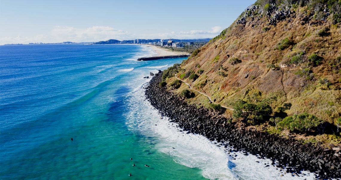
Also thanks to the global monitoring satellite technologies developed by Telespazio and e-GEOS, Leonardo is committed to defending the environment and ecosystems on a number of fronts, starting with combating coastal erosion. A theme that today will take us to the beaches of Australia's Gold Coast.
According to a study published in 2020 by Nature, one of the world's most prestigious and accredited scientific journals, about 50% of the world's beaches could disappear by the end of the 21st century. Erosion is to blame, largely due to the normal action of atmospheric agents such as wind and salt, but often amplified by ill-considered human actions and climate change.
Satellite systems have proven to be a strong ally for monitoring and combating this phenomenon. This is why the European Space Agency (ESA) and Future Earth, the United Nations programme that funds climate change studies, have chosen Telespazio – a joint-venture between Leonardo (67%) and Thales (33%) – to develop, through its subsidiary Telespazio UK, a demonstration project that investigates post-storm beach recovery.
The case study is the Australian Gold Coast: over 70 km of beaches on the continent’s eastern coast, just south of Brisbane, a popular destination for tourists and surfers from around the world. However, it has a history of severe erosion problems, worsened by violent typhoons and storms that periodically sweep the area.
To understand the relationship between waterline fluctuation and erosion or accretion, in partnership with the Coastal and Marine Research Centre – an Australian scientific institute that studies local coasts and seas – since July 2020, Telespazio UK has been analysing and processing data collected by the Sentinel-1 radar satellite of the European Commission's Copernicus Earth Observation programme and the Climate Change Initiative’s Sea State project programme, which gathers data from several European missions.
The project intends to create a historical database with encoded information on erosion trends over time on the Gold Coast. The aim is to identify future trends and increase the resilience of coastal communities by assisting them to mitigate the effects of storms and, finally, study in detail the link between climate change and coastal erosion.
For example, the team has already analysed the impact on coastlines of Cyclone Marcia, which hit eastern Australia in February 2015, causing more than half a billion dollars' worth of damage. This project has also studied the role in coastal erosion of the so-called 'Australian east coast low', very intense low-pressure systems that cyclically batter the country, causing heavy rains, winds and flash flooding. In total, 318 Sentinel-1 images were used, analysing 270,000 waterline points between 2015 and 2020.
The aim is to present the results of the Australian Gold Coast project at the World Climate Conference, to be held in November 2021 in Glasgow (COP26). Eventually, Telespazio also hopes to extend the initiative worldwide, employing Machine Learning and Artificial Intelligence (AI) tools to improve the capacity for analysis, the introduction of standard models and the use of higher resolution data – both in the radar domain, such as using COSMO-SkyMed, and in the optical domain.
Protecting the planet is central to the 2030 Agenda of the UN sustainable development strategy. According to some estimates, 50% of the world's GDP depends on nature, and every dollar invested in its restoration creates up to $30 in economic benefits1. Furthermore, ecosystem degradation is already adversely affecting at least 3.2 billion people (40% of the world’s population)2. At the same time, soil erosion and other forms of degradation cost the world more than $6 trillion per year in terms of lost food production and the loss of other ecosystem services3.
Terrestrial monitoring applications are again proving to be the most direct way to achieve concrete benefits. Having the possibility of obtaining information from the extra-atmospheric data provided by the sensors on board the satellites - from radars to electro-optical instruments and hyperspectral instruments, true technological masterpieces developed in Leonardo's laboratories - and combine it with terrestrial technologies, such as AI and HPC (High Performance Computing), makes it possible to develop services and solutions that contribute to improving the living conditions of citizens.
The development of space technologies in this direction is one of the pillars of the 'Be Tomorrow - Leonardo 2030' strategic plan and Leonardo's Sustainability Plan.
For example, the Space Technologies Leonardo Lab – part of the network of Leonardo's technological research incubators for long-term research – aims to develop AI applications for Earth monitoring, combining satellite and drone data with other data to create surveillance tools for critical infrastructure, natural events, search and rescue, environmental monitoring, big events, health emergencies, smart cities, border control and security. The laboratory's work will help create innovative Machine Learning/Deep Learning methods and algorithms for global monitoring systems and Drone Service Provider solutions. Technologies that literally give space to the future. Even to that of the planet.
Sources:
1 Journal of the Society for Ecological Restoration
2 IPBES - Intergovernmental Science-Policy Platform on Biodiversity and Ecosystem Services
3 Sutton et al., 2016